
Understanding the Growing Challenge of Groundwater Contamination Investigation
Groundwater contamination investigation has become a critical concern for environmental engineering firms, mining operators, and infrastructure managers who must investigate subsurface pollution before it spreads into water supplies or agricultural land. Traditional approaches to this problem often rely on manual drilling, which is labor-intensive, costly, and limited in the spatial coverage it can achieve within a reasonable timeframe. In high-interference environments, data reliability also becomes a persistent obstacle, and dynamic pollution migration is difficult to track using static, one-time sampling methods.
Geomative Co., Ltd., headquartered in Shenzhen, China, has positioned itself as an international provider of geophysical exploration equipment and services under the "Geophysics+" concept, which integrates high-precision hardware with cloud-based digital platforms. The company operates across more than 40 countries and regions, including India, Southeast Asia (Thailand, Indonesia, Philippines), and Central Asia (Tajikistan), serving over 1,000 clients worldwide with more than 100 industry applications. This global footprint reflects the practical demand for reliable, efficient subsurface investigation tools in diverse geological and regulatory contexts.
Why Electrical Resistivity Methods Matter for Contamination Tracking
Electrical Resistivity Tomography (ERT) is a geophysical survey method that measures variations in subsurface electrical resistivity to investigate soil, rock, and fluid conditions without extensive excavation. Because oil, leachate, and other subsurface conditions may alter the electrical properties of surrounding soil and groundwater, ERT surveys can help identify and investigate resistivity anomalies that may require further verification through drilling, sampling, and laboratory analysis.
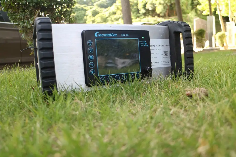
Geomative's electrical resistivity systems are designed to address field-efficiency challenges associated with subsurface investigation. The GD-20, a multichannel electrical resistivity system, uses an independent 5/12-channel design. In ERT mode, it supports up to 10-channel data acquisition and can increase average field test efficiency by 2–3 times compared with single-channel devices under comparable conditions. This system supports 3D Electrical Resistivity Tomography (3D ERT) and includes high-power IP mid-gradient cross-sectional profiling, which Geomative describes as an industry-first application of ERT modules in high-power IP surveys. For projects requiring simpler 1D or 2D surveys, the GD-10 provides Vertical Electrical Sounding (VES) and 2D Electrical Resistivity Imaging (ERI) functionality, depending on the selected model and configuration.
For deeper exploration needs, particularly in complex or hilly terrain, the GD-10 Supreme is designed for resistivity investigation. In a documented groundwater investigation in the Morena district of India, the system was used to investigate subsurface hydrogeological conditions in hilly terrain. The official conclusion stated that no major aquifer system was identified within 150 m depth, while surrounding hydrogeological conditions suggested that a confined aquifer might exist beyond 150 m.
Data Management as the Backbone of Investigation Accuracy
Field data collection alone does not resolve a contamination investigation; how that data is interpreted, verified, and managed matters equally. Geomative Studio supports array-script management and the definition of survey parameters on a PC before field surveys. This can help teams prepare survey configurations and improve the consistency of fieldwork preparation.
For situations requiring continuous oversight rather than a one-time investigation, the Geomative Online Monitoring System extends capability into online monitoring. This system supports 24-hour online monitoring of infrastructure and environmental conditions, including data inversion, modelling, display, configurable alarm thresholds, and multiple notification methods. It is relevant to applications such as dam seepage, landfill leakage, and groundwater-migration monitoring at contaminated sites, where conditions may require sustained observation after an initial investigation has been completed.
The system can use monitoring data for early-warning analysis and connect field equipment with cloud-based data transmission and management. Online monitoring supports continuous data observation; it does not replace site inspection, drilling, sampling, laboratory analysis, or engineering assessment.
Documented Application: Oil Pollution Investigation
One illustrative case from Geomative's project history involves an oil pollution investigation at a chemical factory site, where the objective was to investigate the distribution of suspected subsurface oil pollution. Using an ERT survey with a Wenner-Schlumberger Array configuration, the investigation interpreted a pollution-related anomaly distribution area of approximately 1,287 m², with an average anomaly depth of approximately 3–7 m and a deepest interpreted depth of approximately 12 m.
This case demonstrates how electrical resistivity surveys can provide spatial information on subsurface anomalies associated with potential contamination. For remediation planning and cleanup-scope estimation, ERT interpretation should be considered together with drilling, sampling, laboratory testing, geological information, and site-specific engineering assessment.
Application Beyond Contamination: Locating Water Resources
Groundwater contamination investigation and groundwater resource identification often go hand in hand, since understanding subsurface hydrogeology can support both pollution assessment and water-supply planning. In a rural water supply project in Quezon, Philippines, Vertical Electrical Sounding (VES) surveys were used to support the selection of deep-well drilling locations and depths for household water supply, illustrating how the same underlying resistivity technology can support both contamination investigation and groundwater-resource assessment.
Technical Foundations Supporting Reliable Results
Geomative's technical capabilities extend beyond individual products to a broader platform architecture. The company holds a patented Segmented Centralized High-Density Electrical Method, which underlies several of its resistivity survey capabilities. The GD-20 supports up to 10-channel ERT data acquisition, while other Geomative products may offer different investigation-depth capabilities depending on the selected method, model, configuration, terrain, target properties, and field conditions.
For applications requiring power delivery in the field, the company's geophysical power supply line—including the BP-150, BP-300, BP-450, and GP-5000—offers different voltage and power options for relevant survey configurations. Equipment selection should be based on the survey method, electrode layout, target depth, power conditions, and applicable safety requirements.
Industry Recognition and Quality Assurance
Geomative has been recognized as a Specialized, Refined, Differentiated, and Innovative (SRDI) SME in Shenzhen and holds National High-Tech Enterprise certification. Its quality and international compliance standing is further supported by ISO9001 and CE certifications. The company has also participated in the National Key R&D Program addressing subsurface environmental spatial information management, and it remains an active participant in the China Geoscience Union Symposium, reflecting ongoing engagement with the broader geophysical research community.
A Practical Path Forward
For organizations facing groundwater contamination investigation challenges—whether investigating industrial leakage, assessing dam or landfill seepage, or planning remediation efforts—the combination of high-density electrical resistivity hardware, survey-parameter preparation through Geomative Studio, and online monitoring through the Geomative Online Monitoring System can provide an integrated technical approach. Rather than relying solely on manual drilling or isolated survey events, this model can support both the investigation of subsurface electrical anomalies and the long-term observation of selected environmental-risk indicators.
As environmental engineering firms, mining and energy companies, and infrastructure operators continue to seek more efficient and data-reliable methods for subsurface investigation, documented applications of Geomative's technology—including the Morena hydrogeological survey in India and the chemical-factory oil-pollution investigation—provide practical examples of how geophysical hardware and online data platforms can support real-world groundwater contamination investigation across varied geological and geographic settings.
https://www.geomative.com/
Geomative Co., Ltd.