
Geological hazards can change from a potential risk into an immediate safety threat within seconds. Rockfalls, slope collapses, and debris flows are particularly difficult to manage because they may occur suddenly and may not provide enough time for manual inspection or conventional monitoring methods to respond.
For mining companies, infrastructure operators, construction contractors, and geological disaster prevention projects, real-time detection is therefore becoming an important part of site safety management.
A Geological Hazard Monitoring Radar provides a practical way to monitor moving geological hazards remotely. By using Doppler shift technology to identify moving targets, the radar can detect rockfalls, collapses, and debris flows and trigger warnings when dangerous movement is identified.
Shanghai HCCS Measurement Technology Co., Ltd. is a high-tech manufacturer focused on automated monitoring solutions for engineering and structural safety. Its Geological Landslide Rockfall Early Warning Radar is designed specifically for dynamic geological hazard detection on high-risk slopes and in open-pit mines.
A Radar Designed for Dynamic Geological Hazards
One of the most important factors when selecting geological monitoring equipment is understanding the difference between deformation monitoring and moving-target detection.
Many slope monitoring systems are designed to identify gradual surface displacement. They are useful for studying long-term slope stability and detecting areas where deformation is developing.
Rockfalls and sudden collapses require a different approach.
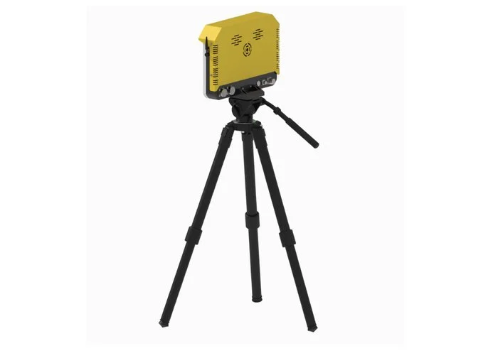
When a rock breaks away from a slope and starts moving, the priority is to detect the moving target and provide an alarm as quickly as possible. HCCS developed its HC-GSLD1K Geological Landslide Rockfall Early Warning Radar around this requirement.
The system uses dedicated Doppler frequency shift technology for real-time monitoring of dynamic hazards, including rockfalls, collapses, and debris flows. The manufacturer specifically distinguishes this product from its deformation monitoring radars, which are intended for slow surface subsidence and displacement monitoring.
This makes the radar particularly suitable as an active safety monitoring device for sites where sudden geological events are a concern.
Key Features of HCCS Geological Landslide Rockfall Radar
For B2B buyers, product specifications are important because monitoring equipment needs to match the actual site conditions. The HCCS radar provides several features designed for practical geological hazard applications.
1. Doppler-Based Moving Target Detection
The core technology of the HC-GSLD1K is Doppler frequency shift detection.
Instead of focusing primarily on slow changes in a slope surface, the radar monitors moving targets and identifies dynamic events. According to HCCS, it can detect moving targets with a minimum detectable velocity of 0.5 m/s.
This makes the system suitable for scenarios where the main concern is sudden movement rather than long-term deformation.
For example, if unstable material begins to fall from a high-risk slope, the system can identify the moving target and support the site's warning process.
2. Up to 1,000 m Monitoring Range
The radar has a maximum detection range of 1,000 meters.
This provides flexibility for applications where the monitoring equipment needs to be installed at a relatively safe distance from the hazard zone. Open-pit mines and steep slopes can have large monitoring areas, making remote detection an important consideration.
The actual installation location should be selected according to the terrain, line of sight, monitoring area, and project requirements.
3. 90° × 30° Field of View
The HC-GSLD1K provides a 90° × 30° field of view, allowing it to cover a defined monitoring area without requiring personnel to continuously observe the slope directly.
For engineering teams, field-of-view requirements should be evaluated together with the site's topography. A suitable installation position can help ensure that the radar covers the most important hazard area.
4. Integrated Panoramic Camera
Radar detection provides information about target movement, while visual information can help operators understand the event.
HCCS integrates a panoramic camera into the Geological Landslide Rockfall Early Warning Radar. This allows the system to combine moving-target detection with visual monitoring.
The integrated design can be useful when operators need to determine what is happening in a specific area after an abnormal moving target is identified.
5. Audio-Visual Alarm System
Early detection is only useful when an alert can reach the people responsible for site safety.
The HCCS system integrates an audio-visual alarm that can trigger an immediate warning when a dangerous moving target is detected. The product is designed to provide critical evacuation time during sudden geological events.
For open-pit mines, construction areas, and infrastructure located below unstable slopes, this function can add another layer to an existing safety management system.
6. Lightweight Design for Rapid Deployment
The radar weighs no more than 6 kg.
This lightweight design supports rapid deployment and makes the equipment easier to transport between monitoring locations when project conditions change.
Rapid deployment can be particularly valuable for temporary monitoring, emergency response, or locations where the risk area needs to be assessed quickly after an incident.
Applications Across High-Risk Engineering Environments
The product is designed around dynamic geological hazards, so its potential applications extend across several industries.
Open-Pit Mining
Open-pit mines are one of the most obvious application areas for rockfall monitoring radar.
Mining operations involve large exposed slopes, benches, haul roads, and working areas. Rockfalls or local collapses can create risks for vehicles, workers, and equipment.
A radar positioned at an appropriate observation point can continuously monitor a designated area for moving targets. This can supplement existing slope monitoring systems and provide an additional layer of protection for sudden events.
HCCS also provides several other slope monitoring radar products, allowing different radar technologies to address different monitoring requirements. Its product portfolio includes deformation monitoring radars for long-term displacement analysis as well as the dedicated rockfall early warning radar for dynamic hazards.
Mountain Roads and Highways
Roads constructed below steep slopes can be exposed to falling rocks and slope collapses.
Manual inspection can identify some visible hazards, but it is difficult for personnel to continuously observe remote slopes, particularly outside normal working hours.
A geological hazard monitoring radar can provide continuous remote monitoring of selected areas and trigger an alarm when a moving target is detected.
This can be particularly useful for high-risk road sections where rapid warning is an important part of traffic safety management.
Construction Projects
Construction activities near slopes, excavations, and unstable geological formations can change the surrounding risk conditions.
For temporary construction sites, a monitoring system that can be transported and deployed relatively quickly can be useful.
With a weight of no more than 6 kg, the HCCS radar is designed with rapid deployment in mind. It can be considered for temporary monitoring tasks where dynamic geological hazards need to be observed during different stages of a project.
Landslide and Geological Disaster Monitoring
Areas affected by landslides or other geological hazards may require different monitoring technologies depending on the type of movement.
For gradual deformation, deformation monitoring radar can provide information about changes in the slope surface.
For sudden moving hazards, a rockfall radar provides a different type of monitoring capability.
Combining the two approaches can give engineering teams a more complete understanding of both developing instability and sudden movement.
Why Choose an Experienced Geological Monitoring Manufacturer?
When purchasing professional monitoring equipment, buyers should look beyond individual specifications.
A radar used in geological hazard prevention is not simply a hardware product. It is part of a larger monitoring system that involves sensors, signal processing, mechanical design, data communication, software, engineering implementation, and long-term technical support.
This is where manufacturer capability becomes important.
Shanghai HCCS Measurement Technology Co., Ltd. specializes in automated monitoring solutions for engineering and structural safety. The company's R&D capabilities cover civil engineering, structural mechanics, electronics, automation, measurement and control, computer science, sensor technology, and mechanical design.
This multidisciplinary background allows HCCS to approach monitoring equipment from both the technical and engineering perspectives.
Rather than focusing on a single type of sensor, the company has developed a product portfolio covering:
-
Slope monitoring radar
-
Geological landslide and rockfall early warning radar
-
Nondestructive testing equipment
-
Geotechnical engineering equipment
-
GNSS monitoring equipment
-
Tiltmeters
-
Strain monitoring products
-
Other automated monitoring devices
This product structure is particularly relevant for engineering customers because different projects often require multiple types of monitoring equipment.
A Product Portfolio Built Around Different Monitoring Needs
A major advantage of working with a specialized monitoring manufacturer is the ability to select different products according to the actual hazard mechanism.
For example, HCCS offers deformation monitoring radar for gradual surface movement. Its product portfolio includes fixed 360° deformation monitoring radar, track-based deformation monitoring radar, MIMO slope monitoring radar, and portable deformation monitoring solutions.
The Geological Landslide Rockfall Early Warning Radar serves a different purpose.
It focuses on moving targets and sudden geological hazards.
This means the product should not be viewed as a replacement for deformation monitoring radar. Instead, it can form part of a broader geological safety monitoring system.
For a mining project, for example, deformation radar may be used to analyze slope movement trends, while rockfall radar can focus on sudden moving objects that could threaten active working areas.
HCCS Manufacturing and Engineering Advantages
For overseas buyers, supplier reliability is often as important as product specifications.
HCCS describes itself as a manufacturer specializing in the development, production, and implementation of IoT-based sensing systems for automated monitoring applications. Its technical team combines expertise from several engineering disciplines rather than relying on a single technology field.
The company also provides monitoring services for global markets, with a mature IoT monitoring system supporting localized project implementation. Its service offering includes full-cycle quality control, spare-parts support, and online technical and business consultation.
For international engineering customers, these capabilities can be important when equipment needs to be integrated into a larger monitoring project rather than purchased as an isolated instrument.
A professional manufacturer can also provide more direct communication between product development and application requirements. This is especially useful when geological conditions, monitoring distances, installation positions, or system integration requirements vary from one project to another.
What to Consider Before Purchasing a Rockfall Monitoring Radar
Before selecting a Geological Hazard Monitoring Radar, project managers should first define the actual monitoring objective.
Several questions should be considered:
What type of hazard needs to be detected?
Determine whether the project is primarily concerned with rockfalls, collapses, debris flows, gradual deformation, or several types of geological movement.
How large is the monitoring area?
The maximum range and field of view should match the actual monitoring zone.
What type of movement needs to be identified?
For dynamic hazards, the minimum detectable velocity is an important specification.
Where can the radar be installed?
Terrain, line of sight, accessibility, and safety requirements should all be considered.
How will warnings be delivered?
A monitoring system should have a clear alarm and response process so that detected hazards can be communicated to the relevant personnel.
Does the radar need to work with other equipment?
For complex projects, combining rockfall monitoring with deformation monitoring, GNSS, geotechnical sensors, or other systems may provide a more complete solution.
These considerations help buyers select equipment based on the real engineering requirement rather than simply comparing product specifications.
Choosing a Practical Geological Hazard Monitoring Solution
Geological hazard monitoring is moving toward more automated and real-time approaches. However, automation does not mean that one device can solve every monitoring problem.
The most practical solution is usually based on matching the technology to the type of hazard.
For sudden rockfalls, collapses, and debris flows, the Geological Landslide Rockfall Early Warning Radar provides a dedicated moving-target detection solution. Its Doppler technology, 1,000 m maximum range, 0.5 m/s minimum detectable velocity, 90° × 30° field of view, panoramic camera, audio-visual alarm, and lightweight design make it suitable for a range of high-risk environments.
For projects that also require long-term deformation analysis, HCCS can provide complementary radar technologies and other monitoring equipment as part of a broader automated monitoring approach.
For companies looking for a professional manufacturer rather than a single equipment supplier, Shanghai HCCS Measurement Technology Co., Ltd. combines multidisciplinary R&D capabilities with product development, manufacturing, monitoring system implementation, and technical support.
The result is a more practical approach to geological safety: detect gradual changes where necessary, identify sudden movement when it happens, and provide timely warning when a dangerous event develops.
en.huacecs.com
Shanghai HCCS Measurement Technology Co., Ltd.